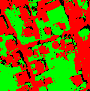
(green: pervious, red: impervious, black: shadow)
For many tasks in urban
drainage (master planning, rainfall-runoff modelling etc.) more or less
detailed information (e.g. percentage of roads, roofs and green spaces
or only the whole impervious area) about the land-cover of the
investigated catchment is necessary. Until now these data are manually
acquired from maps, arial photographs and by on site inspection. This
manual determination is time-consuming and hence expensive especially
for large catchments with high imperviousness.
The present method was developed at the department of
engineering science of EAWAG. It achieved good results compared to a
manual digitalisation. Newer investigations with high-resolution satellite images (IKONOS) also show good results.
The aim was to develop a
processing of the color and infra-red images as automated as possible
to determine the imperviousness in urban catchments and to test the
procedure in practice in collaboration with an engineering company.
The following presented
automatic determination of surface types from aerial photographs only
allows the discrimination between impervious and pervious areas.
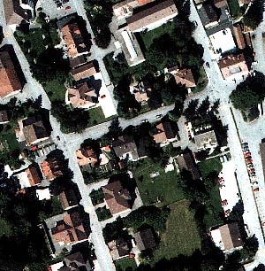
A digital
color aerial image or an orthophoto (a georeferenced and geometrically
corrected aerial image that fits the map) is the basis for the
classification. The digital image consists of squared image points
(pixels) of a certain ground resolution (0.2 - 1.5 m). The digital
image is created from a scan of an analogue aerial image (23x23 cm) or
directly shot with a digital camera. Each pixel contains a color
information in the form of three numbers which represent the brightness
values of the base colors red, green and blue (RGB). Satellite and
infrared images has additional brightness values from other spectral
ranges (so-called channels) of the electromagnetic radiation
(near or far infrared, thermal radiation).
A
multispectral classification is used to assign each pixel to a
land-cover class based on its color or spectral information. A
brightness distribution for each spectral range is determined by
analyzing multiple regions (training sites) of pixels for each ground
class by hand. Based on these brightness distributions each pixel of
the orthophoto is assigned to a land-cover class by means of the
maximum likelihood method. In a next step the land-cover classes are
aggregated to two classes «pervious» and
«impervious». Figure 1 and 2 show the original orthophoto and classification result.
| |
|
|
| Fig.1: original color orthophoto |
Fig.2: classification (green: pervious, red: impervious, black: shadow) |
The
method was tested in various catchments. The differences to a
determination by manual digitizing of the impervious areas are less
than 10%.
André Rotzetter + Partner AG, Zug
Swissphoto Vermessung AG, Watt